Interdisciplinary Innovation: TCU Undergraduates Collaborate with Patagonia Books Using GIS Technology
When Patagonia Books set out to promote two new titles focused on environmental awareness,
they turned to Texas Christian University. TCU’s geography department, known for its
innovative geographic information system (GIS) curriculum across multiple colleges,
stood out in part because of the university’s ongoing relationship with Esri, a leading
geospatial technology company.
Over the course of the multi-semester collaboration, students in schools across campus
worked to design interactive Esri StoryMaps that brought the books’ themes to life
through data, maps and multimedia.
“These were not class assignments,” said Sean Crotty, associate professor of geography
in TCU’s AddRan College of Liberal Arts. “We wanted the students to be able to produce
work that wasn’t just for a grade but that actually had an audience and impact beyond
campus. Our students were doing graduate-level work for a global company, and Patagonia
is now using their StoryMaps as part of its official promotional strategy. That’s
a remarkable accomplishment for undergraduates.”
TCU’s team of four undergraduate students – Olivia Dugger ’25, Ainsley Elliott ’25, Carolyn Kennett ’25 and senior Chi Hoang represented
five colleges and multiple majors – geography, supply chain, fashion merchandising, and digital culture and data analytics. 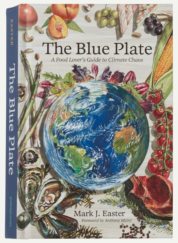 Crotty co-led the project with Kyle Walker, geography department chair and professor.
The project supported The Blue Plate: A Food Lover’s Guide to Climate Chaos by Mark J. Easter and Into the Thaw: Witnessing Wonder Amid the Arctic Climate Crisis by Jonathan Waterman. Each book called for a different creative approach.
Crotty co-led the project with Kyle Walker, geography department chair and professor.
The project supported The Blue Plate: A Food Lover’s Guide to Climate Chaos by Mark J. Easter and Into the Thaw: Witnessing Wonder Amid the Arctic Climate Crisis by Jonathan Waterman. Each book called for a different creative approach.
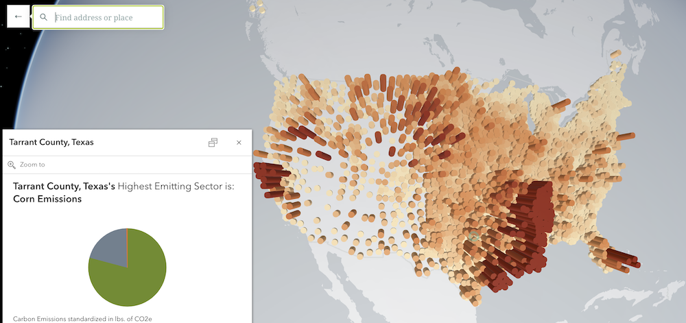
“For The Blue Plate, our students conducted original research that expanded on the book’s themes, creating
data-driven visualizations and geospatial analyses of agricultural systems,” Crotty
said. “For Into the Thaw, they developed an immersive 3D narrative retracing the author’s Arctic expedition
route, incorporating satellite imagery, multimedia elements and interactive mapping
to create a deeply engaging user experience.”
Hoang, a double major in fashion merchandising and digital culture and data analytics,
remembered being drawn in right away. 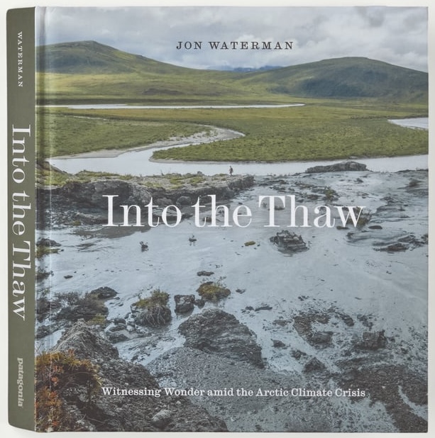 “When I got the email notification about the project, I had just gotten out of my
Sustainability in Fashion class,” Hoang said. “In that class, we learned about fashion
corporations and their sustainable strategies, and what Patagonia did literally brought
me to tears. When I heard about the project, it felt like fate.”
“When I got the email notification about the project, I had just gotten out of my
Sustainability in Fashion class,” Hoang said. “In that class, we learned about fashion
corporations and their sustainable strategies, and what Patagonia did literally brought
me to tears. When I heard about the project, it felt like fate.”
Hoang brought expertise in digital storytelling and user experience and even proposed
the concept for the flagship visualizations. She said the most exciting part was also
the most challenging: the hunt for data.
“Fifty percent of the job was finding the right data and then cleaning and engineering
it toward our needs,” Hoang said. “I used to believe I needed to be prequalified for
the job, but this project taught me to trust my ability to adapt and absorb new skills.”
Dugger was a triple major in Italian, geography, and digital culture and data analytics
and is an Honors Laureate of the John V. Roach Honors College. She now works at Esri
and said the experience gave her an early taste of professional responsibility.
“This project gave us the chance to step into a professional role, communicate directly
with a partner organization and create deliverables that aligned with their needs,”
Dugger said. “That’s a great responsibility for college students, and knowing that
this opportunity was really special stood out to me throughout the experience.”
The diversity of majors on the team became one of its greatest strengths.
“I brought my background in geography and data visualization, and I worked closely
with students who had expertise in business and multimedia design,” Dugger said. “Working
together pushed me to think beyond the technical side and focus on how maps are most
powerful when designed with an audience in mind. That balance kept me grounded in
the ‘why’ behind everything I contributed.”
The result impressed Patagonia’s publishing and marketing teams, who integrated the
StoryMaps into their outreach efforts. For the students, the project bridged classroom
learning with global issues like climate change and gave them confidence in their
own abilities.
“One of the most exciting aspects was seeing students from different majors learn
from each other and combine their expertise into something cohesive and meaningful,”
Crotty said. “It’s rare to see students from fashion, geography, supply chain and
data analytics working together, but this project really showed how powerful that
collaboration can be.”
By blending their diverse skills and perspectives, the students didn’t just complete
a project. They created work that reflects the kind of hands-on, unique interdisciplinary
experiences that define a TCU education.
“Our work with Patagonia Books exemplifies TCU’s commitment to academic excellence
and meaningful engagement,” Dugger said. “It showed me how TCU prepares students to
take on leadership roles, build relationships with external partners and deliver work
that makes a tangible impact.”
This collaboration highlights TCU’s leadership in geospatial education. TCU is one
of the only universities in the country preparing students in GIS technologies across
multiple colleges and disciplines, giving them rare opportunities to apply these skills
in real-world projects.
Explore The Blue Plate StoryMap and the Into the Thaw StoryMap.
–Riane Cleveland